Thursday 15 May 2014

Day seven, Kinglochleven to Fort William, Saturday 10th May.


We left our luxury B&B having had a substantial breakfast!

The guidebook had us down for 15 miles, we had a train to catch so we had to crack on.
Camera was packed away as rain was forecast for the day, we set off in water-proofs a gentle walk through the village the Way turns right up a track, there was a notice about a meeting at Lundavra that hopefully wouldn't disrupt the pleasure of the walk.

As we walked up the first part of the track a couple on mountain bikes came skidding to halt.

A gentle rise through some woods, we could hear a motorcycle engine in the distance, before long a trials bike zoomed passed us, this would keep happening for the next couple of hours, as we walked up the track zig zagging,to ease the gradient, not to strenuous a climb.


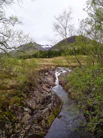
Once we had cleared the woodland there were views down into Loch Leven and the Pap of Glencoe, further on we could see Beinn na Caillich on our side of the Loch.


We now had a gentle walk uphill for about 4 miles reaching a height of 1100 feet at the top of the pass between the hills on our left and the Mamores on our right.


There was the continual interruption of the trial bikes as we continued our walk, try as i might to capture these fast moving bikes with my glorified point and shot, it was very hit and miss!


The Way eventually swings north following the glen around the west end of the Mamores, there has been a major tree felling operation that has taken place ages ago, now the landscape looks bleak and stark with all the tree stumps left upturned.


Gives views across to Lochan Lunn Da-Bhra, there is an information board telling us we are half way, it is here that the Way leaves the military road, and strikes up a short steep hill, Blar a Chaorainn.


When we had reached the summit we stopped for our final lunch taking in the views north west over an invisible Fort William, and north east towards Ben Nevis, the view back was hidden by the hill we had just skirted round.


From here we dropped height and walked in the Nevis Forest, the views were limited occasional glimpses of a cloud shrouded Ben.


We walked through more felled forest and climbed again to pass over the col and drop into Glen Nevis. We didn't stop and take a look at the Dun Deardail Iron Age fort but pressed on on a forest track that swept back and forth down the hillside.


We came to a diversion where there was a temporarily path laid nearly straight down the forest side lots of tight zig zags and eventually came out on the forest track again. Here we stopped and I changed into my shorts as the sun was out and it was a very pleasant afternoon walk through the forest. There was a signpost for the town centre via the Braveheart car park, but we kept to the Way and came out of the wood nearly opposite the Glen Nevis Centre.

There was then an arduous walk along the road, past the Braveheart car park and into Fort William. Pass the original terminus stopping at the Woollen Mill shop to collect our official West Highland Way completion certificate!

The Finish is now in the town centre following the pedestrianised high street and into Gordon Square, where we had the compulsory photograph taken sitting with the seated statue.


We had completed the walk, today we had walked 14.01 miles according to the GPS climbed 2241 foot, max ascent was 1109 ft, the heart rate monitor had my heart rate max out at 164, using 4391 calories.

It had been a fantastic walk, arrived in early went to Morrisions for a pot of tea, and a bagful of dressings for Allan's blistered feet.
The train journey back to Crianlarich was spectacular up to Spean Bridge and down by Loch Treig to Corrour Station pass the east end of Blackwater Reservoir, Rannoch Station and back to civilisation at the Bridge of Orchy and in to Crianlarich.
For an overnight stay in the B&B before setting off home on the Sunday morning.

The GPS has us having walked 95.59 miles in total.

In summary we had a fantastic time, both thoroughly enjoyed ourselves, the weather was kind for Scotland.

Writing a Blog was more difficult than I imagined on an Iphone, I used an LX5 Panasonic camera, had an Eyefi wifi card in the camera to transfer the images to the Iphone at the end of each day. I had a Peak Design Capture PRO camera clip complete with Micro plate, this allowed me when the weather was dry to keep the camera attached to a strap on my rucksack so it was always ready and available, this worked seamlessly.
On the Iphone I used Snapseed to do some very basic post processing the small jpeg that I used to illustrate the Blog, the images on  the Iphone look OK but once home and reading the Blog on a calibrated screen the colours are slightly off compared to the RAW images I have imported to  Lightroom.
The real problem was lack of 3G or wifi in the B&B each night so hence the delay in getting the Blog finished and posted.

Monday 12 May 2014

Day six, Kings House to Kinlochleven Friday 9th May

This was to be a relative short day, only 8.5 miles.
Allan had brought with him a book entitled Not The West Highland Way, it made great reading on the way up as he drove. Today was perhaps the opportunity to take a walk from the book.

The routine walk would be out the back of the Kings House Hotel and  up  the "Devil's Staircase" the book suggested a walk into Kinlochleven by a different route.  Follow a minor track north up the stream  then swing north west slightly to slip over Beinn a Chrulaiste at 2803 feet. Then further north east along the spur to take you into Coire Garbh, follow a grassy stream bank out of the coirre heading for Warbrick's Loch, this was the shot I so wanted of the Buachaille. Then follow down over the Blackwater Dam and down into Kinlochleven, 10 miles and  2200 feet of ascent.

The forecast wasn't good, it had rained overnight hard we awoke to heavy rain, there was perhaps the chance of it lifting later. We went into breakfast, I decided against the climbers breakfast as fruit pudding was suet and dried fruit, that would sit very heavy. I wanted to get yesterdays blog posted so we sat in the hotel lounge watched the rain and clouds in front of the Buachaille, chatted to various folks. The lady of the hotel told us of the winter storms, that happened last winter roofs being lifted. That the staff have to have 4 weeks leave these days so they close for December and send them back to  Latvia and Poland for Christmas, so fortunately they weren't open as there was no power. The Kingy doesn't look as if there has been any investment in years apart from new carpets 2 years ago apparently, our room looked on to the Buachaille.


We chatted with 3 girls who were "wild camping" we couldn't get our heads round wild camping and getting your bags transported to your next destination! We at least were carrying our own bags, ok we were a little soft using B&B!

By 11am the cloud base had lifted it wasn't raining so much, we ventured out having decided to take the shorter direct route. Everything was in dry bags as light rain continued, the route follows the A82 for about  three miles, the scenery was amazing.


The path drops down onto the A82, close to Altnafeadh, a lady stepped out of her low profile camper van and accosted Allan. She had driven into the small unofficial carpark and was stuck, could we give her a push? Packs off, got her moving but in the wrong direction, not quite sure how she got in there as her low ground clearance and the steep incline with pot holes was going to make it an interesting escape. She turned round and got out we planned the escape, was going to be tight as she may easily bottom out. After lots of pushing and tyre spinning she was back at the entrance on the main road, we had done our good deed for the day and she was on her way.


Back across the A82 and we were now starting the climb up the Devil's Staircase quite steep but the gradient eased by the zig-zags, the views back up the Glen were stunning, the rain had eased and it was brightening.


Looking forward the view unfurled between Stob Mhic Mhartuin and Beinn Bheag a vista across to the Mamores and perhaps Ben Nevis.


After the saddle the descent begins, to the right is the afore mentioned Blackwater Reservoir.

The views across as we walked were halted by a grouse slowly walking from beside the path, I only had my point and shoot so the images are zoomed digitally!


Soon we are down to the head of the pipeline and we still have over 1000 foot of descent to go in an indirect path that finally joins the 6 pipe line leading down to the back of the old Alcan Works.


 We had ,made good time and stopped off for a tea and shortbread at the Ice Factor, when we came to leave it was pouring down again so we watched some guys on the indoor wall before venturing out to our B&B the Allt na Leven Guest House.
What a gem Allan had found here, would put the King House to shame, we were really spoilt very high standard of finish, wifi and when we looked they did evening meals. So I popped down with our order, Pauline said would 7pm be good, sliped over to the Co op for the wine.


We had a real feast, spent ages chatting with her and Wullie her husband, then retired to our comfortable beds.
The next mornings breakfast was equally enormous as were the packed lunchs.

The heart rate monitor  confirmed an easy day, 2656 calories max heart rate 158, the gps had our max elevation 1798ft, with 1174 total ascent, 6.9 miles.

Friday 9 May 2014

Day five, Bridge of Orchy to Kings House, Thursday 8th May

After a good nights sleep, we had an interesting breakfast. The evening before we had ticked full Scottish, and placed a cross against tomato for me and vegetarian sausage for Allan, as items we didn't require. 
Served with splendour was a poached egg and three halves of grilled tomato, Allan had scrambled eggs and veg sausage, that will teach us to presume!
Our wet boots were returned to us clean and dry, such pleasure to start the day with warm boots.
Today's walk 12.5 miles, we were in for an easy day. The weather looked good as we walked out the B&B and straight on to the WHW.


The view looking back was impressive as we walked through pine forest up on to the moorland with glimpses of Loch Tulla tempting us on.


There was no wind and the reflection on the Loch was impressive. 


The walk down into Inveroran gave a different perspective with views up the Loch with its crannogs (man made wooded islands).


Walking past the Inveroran Hotel we exchange pleasantries with the three girls that shot past us on the way up.
The WHW is fantastic creating comradeship as we keep bumping into the same people at different stages, and catch up as to how they are getting on.


We had a very pleasant slow walk through rolling moorland, pass Victoria Bridge and on to Forest Lodge.
This was the start of the walk over Rannoch Moor on an idilic day. Having driven over the moor many times part of the reason to walk the WHW was this part, to walk one of Britain's wild places and we were having the pleasure to do this on a beautiful day. 


There was a steady climb alongside a plantation on this old military road, the air is so pure the lichens and mosses growing on the twigs made the first of many photographic stops!


We walked clear if the plantation where we had been accompanied by the call of a cuckoo, and the splendour of the scenary unfurled itself, visibility was amazing.


We had a lunch stop at Ba Bridge, roughly half way to Kings House, again exchanging pleasantries with a party of four guys who had passed back at Loch Tulla, they were walking through to Kinglochleven that evening. We cracked open the Grey Gouse in the hip flask it was an excellent day!


We continued on past a few small falls.


We were now on the Black Mount proper,  a high plateau rather than a mountain. The views were amazing across the A82 in the distance.


We passed the ruins of Ba Cottage and gained ascent over the lower most slopes of Meall a' Bhuridh.


We reached the highest point of the walk at 1500 feet, then started the descent into Kings House three miles away.
A gentle walk down pass Glencoe Mountain Resort and the famous Blackrock Cottage.


We were soon in the Kings House, checking in was at the bar as reception was closed, it was just before 4pm we had made good time. The same four guys we had met earlier, were in the bar just finishing their meal. They set off at 5pm to do in the evening what we had planned for Friday! 
We had had an easy day, the heart rate monitor read 2725 calories max heart rate 134! The gps 11.77 miles max elevation of 1453 feet and total ascent of 1657 feet. the first pint slipped down real easy as we sat in the bar before going to our room to shower for dinner, we did check if we need a reservation after the problems of the previous evening!